Ecology Surveys
Ecology surveys vary depending on the season, and for different species.
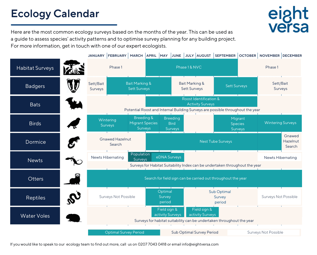
You can plan ahead and understand what is critical in avoiding project delays with our Ecology Calendar or for details on the different types of protected species surveys, see below.
For any more information, get in touch with our expert ecology team.
Habitat surveys (also known as a Phase 1 Habitat Survey) will involve walking around your site to identify the main habitats present such as woodland, farmland, hedgerows. The survey will also highlight key ecological features present within the zone of influence, such ponds.
A Preliminary Ecological Appraisal (PEA) is the first stage in assessing the ecological importance of a site and enables identification of features of particular ecological interest. The PEA collates information gathered from the Phase 1 Habitat Survey and desk study, including purchasing reports from the local record centre and a search for statutory designated sites within a zone of influence, to identify the constraints and opportunities of the proposed development and details any further Phase II surveys which may be required. The PEA is used to inform the evolving design of a project and is used to inform site proposals prior to development.
Ecological Impact Assessment (EcIA) is the process of identifying, quantifying, and evaluating potential effects of development-related (or other proposed) actions on habitats, species, and ecosystems, to ensure no let loss of biodiversity and help enhance ecological integrity. The EcIA identifies the ecological features of the site including results of any Phase II survey, their ecological importance, the impacts, mitigation, compensation and enhancement required to inform a planning application.
Phase 1 Habitat Surveys can be carried out October-March. Phase 1 & NVC April-September.
A species protected from persecution and includes any impacts within close proximity to a sett. Badger populations are dense in the south of England with smaller populations in the centres of large towns and cities. Badgers can be found throughout the countryside including farmland and woodlands.
Our ecologists have worked on a range of rural and urban developments including:
- Survey of extensive badger setts in Waltham Abbey using GIS, in advance of planning
- Creation of artificial badger setts in Harlow, where the main sett was situated in the development area
Badger setts comprise tunnels and chambers that are visible as single or groups of holes, called setts. Entrances are broader than they are high, oval in shape and surrounded by loose soil. Where main setts are threatened by development it is often necessary to replicate these in nearby suitable habitat. Sett surveys involve walking around a site looking for evidence of badger such as sett entrances, latrines, footprints, snuffle holes or badger hairs. If a sett is identified, we aim to classify the sett and to determine if it is active or inactive. Further site visits may be required to classify the sett.
Sett and Bait surveys can be carried out December-January. Bait marking can be completed February-August. Sett surveys February-November.
If a badger sett is active and going to be affected by the proposed development, a mitigation strategy and licence from Natural England may be required.
Roost Assessments – Preliminary roost assessments or scoping bat surveys is the initial phase of any bat survey process. An experienced member of our team will undertake an initial site visit during daylight hours to assess the building/tree/feature for its potential to support roosting bats. Unlike activity bat surveys, roost assessments can be undertaken all year round.
Emergence/re-entry survey – If the preliminary roost assessment identified the building/tree/feature to have bat roosting potential, up to three emergence/re-entry surveys are required to identify and classify any roosts which may be present. These surveys can be undertaken between May and August (core bat survey season), and in some cases, into September for the final survey.
Bat Activity Survey – Bat activity surveys are used to assess the foraging and commuting activity levels of bats using the site. This involves experienced ecologist walking a set transect route around/through the site recoding bat activity. This survey is used in combination with static bat survey where bat detectors are left onsite for 5 consecutive nights, usually monthly, to record bat activity throughout the night. Activity and static surveys are usually undertaken monthly between April and October.
Bat Mitigation & Strategy – If a bat roost is identified on the site, a bat mitigation strategy and licence from Natural England will be required to allow the works to proceed legally. Working with the design team, a mitigation strategy will be developed to either retain the bats onsite or provide suitable mitigation, compensation and enhancements. Forging and commuting bats will also need to be considered in any designs.
Potential roost and internal building surveys can be carried out throughout the year. The inspection of hibernation roosts is viable between November-March inclusive.
Wintering – A wintering bird survey is a survey undertaken during the winter period to assess the species composition and the numbers of wintering birds present. This survey is specifically designed for sites which may hold species of conservation concern during the winter period or is within close proximity to a statutory designated site with birds as its qualifying species. The survey involves three visits by a suitably trained bird surveyors undertaken between November and February inclusive.
Breeding – A breeding bird survey monitors the status and trends of bird populations. Data from the survey is an important source for range maps, field guides and potential long-term population of your property or site. The survey involves visits by a suitably trained bird surveyors undertaken between March-June inclusive.
Migrant – A bird migrant survey monitors the movement and migratory patterns of a wide variety of species of birds. This can be from or to your property, or area. Migrant surveys can be undertaken by a suitably trained bird surveyors between March-April inclusive.
Suitable dormouse habitats include hedgerows and woodlands which are connected and provide a food source and shelter for the species. Surveys of hedgerows and woodland involve a licensed surveyor undertaking present/likely absence surveys by placing nest tubes or nest boxes within these features and if present, dormice will use these to make a nest. Nest tube/nest box surveys can be undertaken between April and November and work on a point scoring system to ensure a valid survey with optimal months having a higher score.
The dormouse also have a distinguishable gnawing pattern on hazel nuts, so if hazel nuts are present, a search can be undertaken to determine if dormouse are present.
The gnawed hazelnut search survey can take place November-March inclusive.
Dormouse are a European Protected Species and as such, if present a mitigation strategy and licence from Natural England may be required to allow the works to proceed legally.
Great crested newt only spend between mid-March and June within ponds and waterbodies with the remaining months of the year being spent in terrestrial habitat such as tussocky grassland, log piles, woodland and hedgerow bases.
Great crested newt surveys involve an initial Habitat Suitability Index (HSI) survey of all ponds and waterbodies within 500m of the site. If the ponds or waterbody is deemed suitable for great crested newt, then a presence/likely absence will be undertaken. This involves a great crested newt licensed surveyor conducting four bottle trapping, egg searching, netting and dusk torching surveys of the pond or waterbody to identify if great crested newt are present. If after the four surveys great crested newt have been recorded, a further two surveys are required to undertake a population size class assessment. These surveys can be undertaken between mid-March and beginning of June with three surveys conducted before the mid-May.
Ponds can also be subject to eDNA surveys, where water samples are taken by a suitably qualified ecologist following a set protocol between mid-April and June. The water samples are then sent to a laboratory, where they are analysed for the great crested newt eDNA.
If great crested newt are identified within ponds or waterbodies within 500m of the site, a mitigation strategy and Natural England licence may be required, or depending on the location of the site, it could be entered into a District Level Licence.
Otter surveys monitor the elusive, rare, and largely nocturnal species and involves a suitably qualified ecologist searching for evidence of otter presence, such as:
- Dung (spraints)
- Tracks (footprints)
- Feeding remains
- Slides (into water)
- Holts (underground dens)
- Couches (above ground sites where otters rest during the day)
Surveys can be undertaken at any time of year, but the best time is spring when evidence is often easier to find as water levels recede and wet mud is exposed allowing, for example, paw prints to be seen more easily.
Reptile survey involve determining if common species of reptile such as common lizard, slow worm, grass snake and adder are present or likely absent from the site and recording the population of the species. Reptiles prefer tussocky grassland, hedgerow, woodland, rivers and pond edges, anywhere with longer grass providing shelter and foraging for the species.
Reptile surveys involve placing suitable refugia such as corrugated metal sheets or bitumen felt in suitable habitat across the site, allowing these to ‘bed in’ for seven days, then conducting a further seven visits during suitable weather conditions to search for individuals. During the survey, basking reptiles will also be noted.
Survey for reptiles can be undertaken once weather conditions are suitable, usually from March-October, although July, August and October are considered to be sub-optimal months for survey.
If reptiles are identified on the site, a mitigation strategy will be required to avoid killing and injury of the species.
Watercourses within and immediately adjacent to proposed development sites should be assessed for their potential to support water voles. A habitat suitability assessment is made, recording and mapping key features such as bank material, amount and type of marginal vegetation, amount of shading from trees, waterbody depth and width, flow velocity, channel substrate and presence of pollution and disturbance.
Water vole surveys for habitat suitability can be undertaken at any time in the year. Field sign and activity surveys can be undertaken from March-October with two survey visits undertaken – one in the early season (mid-April to June) and one in the late season (July to September).
If water vole are identified within watercourses, a mitigation strategy and Natural England licence may be required.
These surveys are likely to be recommended where rivers and streams are affected by development in areas where the white-clawed crayfish is known to be present. Crayfish can be collected by setting funnel-shaped traps along the banks of streams. These traps are set overnight and contain bait to attract the crayfish, which are nocturnal. Other techniques include manually searching under boulders and torchlight (night viewing) surveys.
White-clawed crayfish surveys are undertaken between July and October, and during April. Between November and March, crayfish activity is reduced, and surveys are not so effective. As crayfish breed during May and June, this precludes survey work in that period.
Related Insights

The WELL Factor: Healthy Building Best Practices
Healthy buildings are on the rise. We explore some of the best WELL examples in the market and identify how they achieve their healthy ambitions.

The WELL Building Standard Just Got an Upgrade
The WELL Building Standard has introduced new Real Estate and Operations Ratings alongside a major update to WELL Certification. Here’s what it means for your projects.

Webinar Recording: Shift to Credibility – Certify Your Buildings as Net Zero
In this webinar, we look at how to certify your buildings as net zero, including construction, operation and correct measurement.